
 Turkish
 Deutsch
 Русский
Piri Reis in “Bahriye (Seamanship)”
“The Ceramic Gulf Explained”
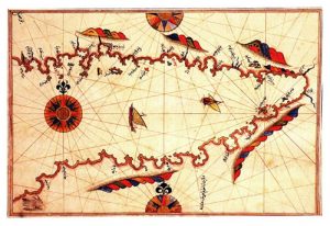
Map of Gökova in the “Bahriyye”. All what the mariner needs to know – in a poetic style.
Piri Reis, the Turkish Admiral, Cartographer and Scholar, describes Gökova in following words (Tercüman, 1001 Temel Eser):
Let us start from the mouth of the Ceramic Gulf. At the start is the fortress Ispot (todays Aspat). It is situated on a steep hill. There are ruins in front of the fortress and here a stream flows into the sea. However, nobody drinks this water. Water requirements are met by water cisterns next to the ruins. With the poyraz blowing, the shores off the fortress are safe anchor grounds. Three miles(Two miles of Piri Reis correspond roughly to one seamile of our times.) to the east there is the island of Gümret (Çelebi Island, the name reminds of Gümbet = Cystern closeby). This and the bay to the west of the island are good anchoring. This is called Bakla Bükü(Bagla Cove). There are streams inshore of the little island, at the cove of Muskubi (Müskebi, Ortakent Yalisi). Three miles east of this island comes the Sigir (cattle) island. The passage between this island and the Anatolian mainland is shallow. Not every ship can pass. The distance from this fortress to Bodrum is six miles. On the way there is a rock awash (the Haremten shoals).
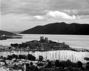
Bodrum is a small castle …
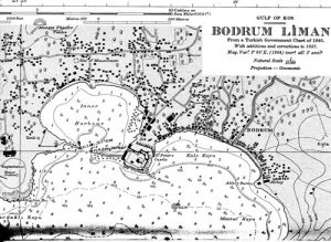
Bodrum town, British Chart, “corrections up to 1953”,
From Kuno Steuben, Abenteuer mit ShangriLa, Ullstein, 1968
Bodrum is a small (sic) castle. There is a nice and wide harbour under the castle. In old times the infidels had boulders spilled south of the castle in order to prevent wind entering the harbour. The harbour is entered amid these rocks. This is because no opening has been left out. There is an island situated five miles off the harbour. It is called Karaada (The Black Island). It is made of steep hills and it is deep around it. This is no anchorage. Up until the cape (Tavsanburnu, The Rabbit Cape) the shores of Anatolia, two miles opposite, are suitable to anchor. Once the cape is rounded after about one mile to the east one arrives at the Kizilagaç(Redtree) Cove. The east cape of this location is called Cape Orak (The Sickle). East of the cape there is an island. This island is called Kicik (Kisle Bükü?), these are deep waters. The cove east of the Kicik island is called Kilisecik (Little Chapel). There is a ruined building. Off this building is an anchorage. Opposite is a small island. East of that island are white sandy shores. There is a stream amidst of them. As the water tastes bitter it is impotable. Ahead of the cape East of this stream there are rocks in the sea. They can be seen at times and they are awash at times. The East side of these rocks is called Kavak Koyu (Poplar Cove). Again when you round this cove towards the East comes the Fesilge Cove (Feslegen, Basilico Cove, Çökertme). Solok (?) of this cove there is a burly cape which is called Cape Fesilge. When that cape is rounded to the east one arrives at estuaries where the kaiks of the levents(able seamen of the Levant) roam. East of these estuaries comes the Kereme (Ceramos) Estuary and there is a cove of the same name. East of the village is a sharp rock. This one is called Kara Burun (The Black Cape). When we proceed to the East we arrive at Akbük (The White Cove) harbour. From this harbour to the root of the Kereme Golf (Ceramic Golf) are ten miles.
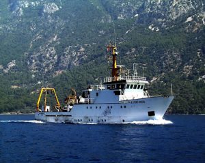
The research vessel of the “Dokuz Eylül Üniversitesi, Deniz Bilimleri Enstitüsü” K. Piri Reis in Gökova off Akbük
The surroundings are grand and lofty mountains. Therefore there are no further anchorages. At the end of the Kereme Golf there is the Gökova Stream. Next to this stream there is another one which is called the Kemer estuary. Boats can enter these streams but the waters are impotable. From these shores to Bodrum are ninety miles. None of the brooks at these coasts are potable. The grounds off the Gökova Stream are white sand, shallow but good holding grounds. In summer it is only exposed to the Imbat (the local westerly offshoot of the Meltemi). Heavy gusts can be expected. When the Imbat blows and anchoring is required, then you pass the Gökova Stream at the North, then one proceeds to the south then veers to the southwest and eventually one arrives at an island five miles southeast of the Gökova stream. This is called Gelibolucuk (little Gelibolu, to distinguish it fom the Gallipoli of the Hellespont. Kalliopolis meaning “Beautiful Township”). It is a good anchorage. But ships larger than galleys cannot enter.
One can anchor only in the passage between the Anatolian mainland and the island. Again, southwest of this one and three miles offshore is another island. It is called Oran (Ören, “the Ruins”) island. This island is embroidered with buildings like the seeds of the pomegranates. It is said that it used to be a large township in the past. Now the buildings are left over. Off here is a natural harbour. Large ships can enter. It has to be entered from the Anatolian direction and from the southwest. Because there is plenty of depth here. To the north there are two islands but the passage between them is narrow and shoal. A galley will pass. Half a mile to the west of this island are rocks, care and prudence is required. Southwest of the island is Sögüt Cove (Karacasögüt). At the mouth of the cove is an island which is a good anchorage. There is no better anchorage here than the Small Günlük (Sweetgum). It is a natural cove. It is wedged between two mountains. It is a huge harbour. It is off the beaten track but even drinking water is available. Not many ships stop here. There are further anchorages in this bay, but if required, consult the chart.